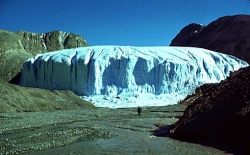
Around two hundred million years ago New York's Finger Lakes and region were created when part of the ocean bottom lifted toward the surface. Two million years ago
a glacier began covering, then retreating, then re-covering the state. Twenty thousand years ago the glaciers from the retreating ice age swept
across what is now
New York State,
the result of these prehistoric events created the Adirondacks and the Finger Lakes as well as
many of the larger natural landmarks. What is now called the 'Thousand
Islands' are the remains of resistant Precambrian bedrock which had not
been eroded away by the currents of the St. Lawrence River. The
Black
River, another river in upstate New York, is one of only a few 'free
flowing rivers' in New York state. The Black River basin area covers nearly
two-thousand square miles and receives the highest annual precipitation
of any watershed in New York State. There are many unique land areas, scenery,
and micro-environments which can be reached via
walking,
biking, and cross-country skiing trails, as well as snowmobiling and all terrain vehicles.
During the time of the ice ages, around 40,000 to 11,000
B.C., the first people (called Paleo-Indians) as well as many
other animals, traveled over what is now called the Bering
Straits (between Siberian Russia/Asia and Alaska, the narrowest part
of which is only forty miles), which were either ice-locked or drained
of their water, and gradually journeyed southward. Some finally settled (anywhere
between eight thousand to eleven- or twelve-thousand years ago)
on the land which is now called
Jefferson
County.
We don't know who these original settlers were as they left no written nor
spoken language, archaeologists call them Paleoindians . Around mid-13th
century settlers who could be positively identified as Iroquoian
(speaking an Iroquoian dialect and having an Iroquoian culture, though they
were not the Iroquois or even the Onondaga but a distinct population we know
as St. Lawrence Iroquoians). (Much of the previous as
corrected by Dr. Timothy J. Abel of the Jefferson County Historical Society.
He also writes: "The Onondaga and Oneida never lived in Jefferson
County. They claimed northern New York, as did the Mohawk, to discourage
European land claims in those regions after the F&I War.")
This tract of land was a main line
of travel from Canada to the Hudson valley region. It was also the site
of many bloody wars and skirmishes between the Canadian Algonquin Indians
and the Iroquois Indians. In almost every part of the county, but especially
in those parts bordering Lake Ontario,
the remains of crude Indian fortifications can be found. These are usually
on hills and unwaveringly face the northwest - from where their enemies
arrived.
It is
said that the St. Lawrence River was discovered in 1535 by Jacques Cartier.
But probably the first non-American Indian to visit what is now New York State
was the Italian explorer Giovanni de Verrazano, when he came across
New York Bay sometime in 1524. Around 1609 or so Henry Hudson
claimed it for the Netherlands and in 1624 a settlement at Fort Orange
was established. But the first European to visit what is now the
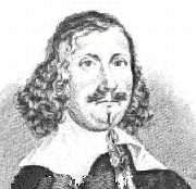
Jefferson County area was more then likely the French explorer Samuel de Champlain
(1567?-1635) who, in the fall of 1615 (five years before the Pilgrims landed,
eight years after the settlement of Jamestown) with a force of 2,500 Indians,
crossed from the "vicinity of Kingston to Galloup and Stony islands and
from thence to near the mouth of Stony Creek in the present town of
Henderson,
where the canoes were concealed in the woods." An unsuccessful campaign
against the Iroquois Indians followed. (Champlain's name was given to
Lake
Champlain, which he discovered. During Champlain's first trip to the
New World in 1599, he also suggested making a canal across the Isthmus
of Panama to shorten the route to the South Sea [Pacific Ocean].)
In 1654 Father Simon le Moine, a Jesuit Missionary,
visited the Onondaga Indians somewhere near what is now the Cape Vincent
area. The next year two more French Missionary priests of the same order,
Father Chaumonoit and Father Dablon, visited the Onondaga Indians on their
way to the Iroquois Country. They traveled the same route from Quebec as
le Moine, and camped at a location now known as Dablon Point on
the south shore of Wilson's Bay.
Later, in the war with Britain, the Oneida Indians
tried to remain neutral, but then fought for the Americans, while some
fought for the British. The North Country at this time was considered something
of a "buffer zone" between the rest of the state and Tory Canada. Canadian
Tories were considered a real threat and were thought to be waiting right
across the border.
Early settlers to the North Country were abandoning
the area because of attacks by Mohawk (the name Mohawk was the Algonquin
word for "Cannibal") and Schoharie Indians.
Around 1665 New York State got its official name
after the English seized the area from the Dutch. It was renamed
"New York" in honor of Britain's James, the Duke of York
and brother of King Charles II.
Sometime during this time period Benjamin Wright and a group of surveyors
inspected the area which is now Jefferson County. Also, in the same year Carlton Island
was fortified from Fort Haldimand (more about
Fort Haldimand on page 2) by the English, and government vessels
were built there for use in Lake Ontario.
Governor George Clinton (1739-1812) talked
to General Washington about the abandonment of outlying areas of the state
by settlers and Washington directed him to act against the Indians, destroying
them. A devastating attack against the Indians of the state was carried
out.
In the summer of 1780 in a battle near Camden, S.C.,
Baron Jean DeKalb, who was a native of Alsace and had been fighting in
our war, was pierced by eleven wounds and killed. The town of DeKalb
was named after him. In 1782 what is now Wolfe Island was named by
the Provincial Governor Simcoe after Major General James Wolfe.
Before that time, the French called the island Grand Island, Isle Buade,
or the Indian name - "Gannin-k-not".
A treaty of sorts was created on October 22, 1784,
between the newcomers and the Indians. The treaty was made secure by a
subsequent
one with the Oneidas when they ceded all of NY's land, except for a small
parcel - a hundred square mile tract in now what is called the Town of
Orleans, called Penet's Square (named after Peter Penet), to the State of New York in 1789. The Indians were still treated as inferior during the making of the treaties
and even after the signing there were still parts of the state where the
war was still proceeding with the Indians.
The US needed an intermediary with the French, who
had helped the country during the war. Benjamin Franklin went to France and stayed
with Jacques Le Ray de Chaumont. Le Ray was a commoner of sorts
and a businessman very sympathetic to America. He also had stock in America
being successful and paying off their debts to him.
Jacques'
son, James, persuaded his father to allow him to go to America, where he
married a NJ resident and became an American citizen in 1788. New
York became the 11th state on July 26th of this year.
On June 22, 1791, Governor Clinton and the
Board of Land Commissioners began to plan on getting Northern NY settled. Alexander Macomb purchased all land in what is now
Jefferson
County; except Penet Square, most of Franklin county and St. Lawrence,
all of Lewis County, and part of Oswego. This was called, appropriately
enough, Macomb's Purchase. Macomb purchased the land on behalf of himself,
William Constable, and Daniel McCormick. After the purchase, the land was
divided into "Eleven Towns".
Macomb went into bankruptcy and Constable sold large
parts of the property to other people in the state. He also went to France
to talk to James Le Ray, thinking the French Revolution might cause many
of the French to move to America. Le Ray invested in land, trying to get
back money his family had lost while helping the Americans. He bought land
in Pennsylvania but traded it for land in
New
York State, and lived in America from 1785 to 1790.
At the end of the French Revolution, Northern New
York did attracted many distinguished French refugees. Though conditions were hard
for these upper classes, circumstances came together favorably for settlement
in Macomb's Purchase. Contributing factors included the bad conditions
in France, the land in the state being rich and valuable, existing prices
lower then in Canada, the lesser chance of interference with British-derived
traditions, and the fact that the French knew that they would be treated
well by the Americans because of the help they gave America.
A tract of land named Castorland was created
by Macomb's Purchase, the land being between Black River and
Lake
Ontario and in the middle of what is now Rome and
Watertown.
This was property put together by the Castorland Company run by Peter Chassanis, Le Ray's brother-in-law. Castorland was created to be a
new France and the company consisted of thousand's of stockholders who
would get land there.
The business was made of four commissioners - Chassanis,
Le Ray, Peter Pharoux; an architect, and Simon Desjardines; an aristocrat. Pharoux and Desjardines sailed from France and, after getting to New York,
met Marc Brunel. Brunel had traveled to the United States to escape the
revolution in France and later designed a successful entry for the
competition to build the new Capitol Building in Washington,
healso
became chief engineer to New York City. He then emigrated to the UK
where he persuaded the British admiralty to make ships blocks by machine,
starting one of the first mass production lines in history. Then he
went on to design the first road tunnel under the Thames, to do this he
invented the tunneling shield. (Info on Marc Brunel provided by Andy
Jarvis).
On the way to upper New York, the group weathered
many a hardship, including meeting and being temporarily held by a British
ship (where Brunel was detained but escaped).
Finally, the party made it to Northern New York. In 1794
the surveyors
and workers spent the hard winter in the North Country, where they built
a large oven, a dugout canoe, and two log houses with a connecting gallery. The surveyors then discovered that they had less land then they had thought,
due to the Black River cutting through the middle
of their properties. They also discovered that
they could not easily travel from one part of their land to another because
of the raging river.
A group went downstream to survey High Falls (Lyon's
Falls), Long Falls (Carthage), and Great Falls (Watertown).
Pharoux and some workers tried to cross the river, being overconfident
from doing it many times before, and found that the poles they were using
for their raft would not reach bottom. They went over Great Falls (at Beebee's
Island [originally Cowan's Island],
Watertown),
where the river falls about a hundred and twelve feet (thirty-four meters).
One workman was rescued by an Indian, but the others and the surveying
equipment were lost.
Pharoux's body was found later in 1795 by Benjamin
Wright and a memorial was constructed on an island in the mouth of
Black River.
Many of the men who had arrived there the previous
spring wanted to go back without ever even having gotten to the winter
months. Numerous men got the "Bloody Flux", what is now known as
dysentery. (See Glossary of Old Diseases and
their present-day meanings)
In 1795, summer probably, the first mill in Carthage
was constructed as well as the town of
Worth
being surveyed and laid out.
Worth
is the most elevated area in
Jefferson
County, rising between twelve-hundred and fifteen-hundred feet above
sea level.
The French settlers in the area had a different attitude
toward the American Indians then the British-derived settlers. The
American Indians
were allowed to roam the settlement and some occasionally even brought
gifts for the settlers. A few were enlisted to help finish the walls of
the mill at Long Falls (Carthage). This good will was marred
by a small disagreement over an alcohol-related misunderstanding.
Benjamin Wright surveyed what is now the town of
Henderson
(Henderson Bay was first called 'Hungry Bay' by English soldiers) and the
South Jeff area in 1796. In May of 1796 it was discovered that money was
not being sent to the Castorland settlement from France. The settlers and
workman tried again in Long Falls (Carthage) but the workman
deserted and someone stole all of the remaining money that the group had
brought.
Around this time a man named Tiller appeared and
told Desjardines that he was sent to replace him as director of the colony. Desjardines left and never returned. Tiller, the new director, was always
in squabbles of some sort from this time onward.
Between 1796 and 1800 twenty aristocratic families
settled in Castorland and Oneida County (which Jefferson County was then
a part of) was begun in 1798.
In 1797 General Henry Champion of Connecticut
purchased "Howard", Town #4 of the Macomb Purchase. Noadiah
Hubbard, his land agent, and a surveyor, Joel Mix, rafted
together down the Black River and staked out their lands in the spring
of that year.
Noadiah
Hubbard Jr. (A distant relative of the compiler of this history) had come from
Connecticut,
also.
Hubbard
is considered to be the first permanent resident of Champion and
in 1798 built a "Bachelor's Hall", which he kept going for two years. He
was "chief cook" at his "hall", which consisted of a crude, three-sided
structure of logs and bark. He was also credited with having the only clock
in Black River Country. In 1799,
Mrs.
Hubbard joined her husband, walking the last four miles from Long Falls
(Carthage) through the forest.
Hubbard
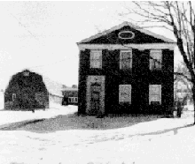
later served in the War of 1812 as a captain. The Hubbard couple built a large
attractive house in 1831, which was later used as a stopping-off point
for runaway slaves en route to Canada. The house remained in the family
until Parnell F. Hubbard sold it on March 7, 1860. (The last known
owners were Mr. and Mrs. Charles A. McCuin.) At this period in the history
of Jefferson County horses were a rarity and oxen were used for transport
and work, though long trips were usually done on foot.
Mix's family also settled in Champion and Mix built
the first sawmill on the river bank.
Between 1861 and 1865 the American Civil War
raged. An "Underground Railway" of the Abolitionists was located
on one of the islands in the Thousands Islands during this time.
Ellisburg
was purchased by Marvel Ellis in March 1797 but reverted to Constable. And in 1798 the NY State Legislature rescinded the regulation allowing
French citizens to hold property in the State of N.Y. Governeur Morris (who in 1782 came up with the idea of decimal coinage [and invented the word "cent"] which later became the basis of the nation's currency) put
Richard Coxe, another brother-in-law of Le Ray, in charge of the inspection
of the Castorland settlement. In 1804 he found the company holdings in
chaos, almost all of the settlers gone, and Long Falls almost deserted. The company had left in debt with only eighty-two acres of land cleared,
eighteen log cabins, a sawmill, and some unusable roads.
Around this time the French government pardoned the
French settlers who had lived in the area and they headed back home to
France. Watertown at this time in history only had four official streets
- Washington, State, Arsenal, and Court.
But more settlers continued to come in. Early settlers
during this time were mostly from Connecticut and Vermont, with a smattering
of people from other areas.
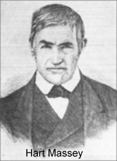
In 1798 Henry Coffeen (a New Englander living in Schuyler, Oneida
County), Zachariah Butterfield, and Hart Massey (29 years
old, from Vermont) built cabins on what is now
Watertown'sPublic Square. After their inspection trip they returned later to get their
families. (It was rumored that Public Square was originally a ravine and
was used as a landfill...)
The year 1799 saw the town of
Brownville
settled by pioneer Jacob Brown, who had been sent as James D. Le Ray's
agent, as well as Brown's wife Pamelia (Williams), and his extended family. Brown was a Quaker from Bucks County, Pennsylvania. The town of
Brownville
at that time included all of present
Brownville,
as well as Pamelia, Lyme,
Cape
Vincent,
Clayton,
Orleans, and a part of the Town of Alexandria.
So little was known of Black River during this time
period (later 1700's) that a map of the time showed it flowing west right
into Lake Ontario.
In the 1800's the state road was extended from
Brownville
to
Cape Vincent. Also around 1800 a developer built a road into the interior of
Rutland,
which derived its name from Rutland, Vermont where most of its settlers
came from. General Brown built a sawmill in 1800, too, and in 1801 a small
grist mill at the mouth of Philomel Creek. Settlement in the town
of
Adams began
and the Town of Champion and
Watertown
were created, making them some of the earliest official townships in
Jefferson
County.
Around 1800, there were about eighty families and
two-hundred or so people living in
Watertown. It was named "Watertown", for
obvious reasons. Around the same time the first town meeting in the county
was held in Champion in the home of the Justice of the Peace, Joel Mix.
Noadiah
Hubbard was elected first supervisor. Also in the early 1800's
a vast array of caverns and caves were discovered under Watertown in the
limestone the city sits upon.
In early 1800 Henry Coffeen returned for his family
and brought them with an ox team on what was known then as old French road.
In the same year the first 'highway' was cut in
the Town of Lyme. It was later abandoned.
Sackets
Harbor and the
Town of Hounsfield were founded in 1801 by Augustus
Sacket, a New York City lawyer. The Village of
Sackets
Harbor was incorporated into the township of Hounsfield, named for
Ezra Hounsfield, who had purchased land nearby.
Noadiah
Hubbard put up a log schoolhouse at the town's expense in Champion
and
in the same year also built one of the first churches in Champion.
Settlement began around 1801 in
Cape Vincent, starting with Captain Abijah Putnam, though the town
was not formed until much later. The first settlement was called Port Putnum. The town has a long French-related history,
evident in some of its oldest buildings.
Clayton,
named after John M. Clayton - a senator from Delaware, was also settled
in 1801 by Captain Bartlett, whose name was given to Bartlett's Point.
Burrville Cider Mill, formerly known as Burr's
Mills and bought and named after Captain John Burr, was built in
1801. It was first used as a sawmill and a gristmill and is located
at the head of the north branch of Sandy Creek on a thirty foot waterfall (also
reputed to be Jefferson County's first brewery).
The waterfall was used to run a turbine that powered the mill's equipment.
There is record of a cider press being in use in the mill as far back as
the 1800's. Captain Burr himself is something of a mystery, but it
was rumored that he was a pirate who would steal from supply ships on Lake
Ontario and then sell the cargo back to the troops at Sackers Harbor.
Some say his ghost still visits the mill.
Le Ray rejoined his sick wife in N.Y. in 1802 and
sold land to Quakers, who founded the village of Philadelphia, NY in 1804.
And also in 1802 the first permanent settler on
Grindstone
Island,
Amariah Howe, took up residence there.
The first seven deeds in
Watertown
were all filed on the same day on August 20, 1802. In the same year Jonathan Cowan built the first mill, a grist mill, in
Watertown
and during the same time period Dr. Isaiah Massey opened a tavern in the area of
what now is Watertown'sAmerican
Corner. Purchases at this time for land were usually made in whiskey,
which was established legal tender in
Watertown.
Some of the first settlers arrived in the town of
Worth
with a few more in the next year. The first settlers to the town of
Lorraine
also trickled in. These first permanent settlers were Elijah Fox,
James
McKee and his wife Sabra, who came from the Rome area on foot. They began
a log cabin immediately.
Henry Coffeen, Hart Massey and others
erected the first bridge across the Black River in 1802 or 1804 and then
tried to dam it in 1806.
In 1800 a gristmill was constructed in Rutland, a
sawmill in 1805, two woolen mills by 1811. Whiskey continued to be legal
tender as well as ciscoes, a kind of whitefish. The Square in
Watertown
was given to the village of
Watertown
to be used as a mall or square, forever. It originally was a ravine which
took many years to fill and was one of the first landfill projects done.
The area's major exports were lumber and potash,
the lumber not always gotten legally, especially in the Penet Square area
(see below). Large rafts of lumber were floated to Quebec and piloted
by American Indians. The rafts were usually fifty-two feet long or so and
might consist of one hundred thousand cubic feet of oak, six-thousand planks.
Adams
was formed from Mexico on April 1, 1802 and named for John Adams. James Le Ray's agents founded what is now the village of Chaumont, after
finding that their first settlement was flooded.
Le Ray made his first trip to the North Country with Governeur Morris
in 1803. They visited
Brownville
and some other areas, finally taking a small boat trip. During this trip,
while camping, they had an incident in which the Governor lost his wooden
leg to a fire in their tent. Le Ray nearly died from an illness he came
down with after being exposed to the elements as a result of the incident.
Jacques, James Le Ray's father, died in this year and James returned home
for three years. During this time he sent his friend and physician to choose
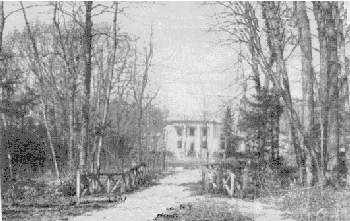
a site for a home in Northern N.Y. The friend found a suitable site on
the edge of Pine Plains (later known as Pine Camp, Camp Hughes, Camp Drum, then
finally Fort
Drum
- see later in this history for more info). A mansion was constructed between 1806 and 1808, but burned
and a second one was built in 1827. The mansion was considered to be the
best west of the Hudson. The mansion was also a base of operations for
the bringing in of new settlers and continued to be a landmark for many
years. Some of the original rose bushes still grow there in present times.
Settlement in Antwerp began.
In 1804 a post office was opened in Champion, the
second in the county and a bridge over the Black River was created at Great
Bend. The first cabin was built in
Worth
and
Rodman was
formed from
Adams
on March 24, having earlier been called Harrison after a previous owner. Seth Cutlar built the first grist mill in the town of
Lorraine.
In the same year a store was being built but a spark from a Miss Andrus'
pipe ignited some shaving and the unfinished construction burned down.
Penet Square was a parcel of land which the
state's Board of Land Commissioners did not control because of an agreement
with the Oneida Indians. Years before, the Indians had ceded the land to
the state, with the Indians insisting that this parcel be considered a
gift to Pierre Penet, who had earlier helped the Indians. Penet was an
aide to Washington and an Indian agent, as well as a gunrunner and owner
of a ship.
The square covered land from French Creek through
LaFargeville and
Perch
Lake. After the War of 1812 it was believed that Penet had died and
many conflicting stories of his death abounded. This caused much confusion
over the ownership of the land and left the large tract free for squatters
of all sorts to stake claim to, some of whom may have come as early as
1795. The squatters usually claimed the land by cutting brush and trees
to mark their perimeters. Most just cut down as many trees as possible,
selling them as black salts, staves, or potash for "a sack of meal, a chunk
of port, and a jug of whiskey." They would then go back to their pitiful
shacks in Penet Square until they had finished their supplies, at which
point they would cut more trees for export.
These squatters were called "Catfish People"
or "Penayers" and considered lower in status then the Indian "savages"
in the state. They got their "catfish" when a dispute needed to be
settled. The name itself may have come from Catfish Falls, the original
name for Depauville.
On March 28, 1805, when
Jefferson
County (named after Thomas Jefferson) was created,
Watertown
was considered the best place for the county seat. The commissioners who
were appointed for the selection of the county seat were Matthew Dorr,
David Rodgers, and John Van Benthuysen. The first court and the first board
of supervisors met at a schoolhouse, the site of a present church. The
first officers were Augustus Sacket, First Judge; Joshua Bealls and Perley
Keyes, Judges; Thomas White, Lyman Ellis, William Hunter and Ethni Evans,
Assistant Justices; Henry Coffeen, Clerk; Abel Sherman, Sheriff; Benjamin
Skinner, surrogate and treasurer; and Hart Massey, Ambrose Pease and Fairchild
Hubbard, Coroners. Most of the taxes of the county were paid for by nonresidents
at this time. Fifteen-hundred people lived in the county, most of whom
were New Englanders and French immigrants. The
Jefferson
County Sheriffs Department, the oldest law enforcement agency in Jefferson
County, was also created in the same year.
Also, during this time the Canadians and the residents
of the North Country had developed a good business relationship with trading. Trading usually was in flour and potash, Potash being an alkaline substance
used in the manufacture of fertilizer, gun powder, and explosives. It was
produced by burning timber, and was selling in Canada for $320 per ton.
A hotel in Watertown, called the White House,
was constructed in 1805. The old Woolworth building stands at this location
now. William Smith, a man who is largely forgotten today and who
had a big influence on the development of Watertown, entered a partnership
with Captain John Paddock to put together Watertown's first store. Smith
also made the first brick yard and built the first brick building in Watertown
known as the Franklin Building, which gave its name to Franklin
Street. He also built the first court house and jail (in 1807-1808 on
Coffeen Street, the jail had four foot
thick walls and doubled as a courthouse, it went through a small fire in 1817
but was burned down in another fire in 1821. The first sheriff was Abel Sherman), the old cotton factory on Factory Square (at the time was
the highest building in the county), the old ship house at Sackets Harbor,
and laid out plans for the buildings at Madison Barracks and was one of
the promoters and a member of the board of directors of the Rome and Watertown
Railroad.
Some sources say that also in 1805 the Watertown
Square was deeded for public use (and called the Mall then). In the
same year the Burrville Society Burying Grounds was started and many early
settlers are buried there, which is now called The Brookside Cemetery.
By 1806 most believed no one owned the Penet Square
land, so some more permanent improvements were made by some of the squatters. The first of the more permanent residents was Roderick Frazier, a farmer,
who built his log cabin in 1806 about two miles north of what is now Stone
Mills. Peter Pratt followed in 1807, making his clearing south of Stone
Mills.
And the first term of court was held in
Watertown
was held in 1807, too. The town of Hounsfield was incorporated on February
17, 1806. William Rice built a gristmill in
Rodman.
(Page
5also contains general info, famous
people, inventions and discoveries from the area, name origins, references,
glossary of old diseases, occupations, immigrants, and legal terms)
Approximate number of visitors: Don't forget to sign or view the guestbook by clicking on LEAVE
MESSAGE above. Use your browser's BACK button to return to here.
If you
have any questions, suggestions, or other feedback you can contact me,
the list owner, from one of the locations below: If
you would like to send feedback, questions, notes, or inquiries
click here for e-mail - -
e-mail
To search this site and/or to be notified of changes do a search below, find the page you want to be notified of changes
to and click the "Monitor page" link.
 Around two hundred million years ago New York's Finger Lakes and region were created when part of the ocean bottom lifted toward the surface. Two million years ago
a glacier began covering, then retreating, then re-covering the state. Twenty thousand years ago the glaciers from the retreating ice age swept
across what is now
New York State,
the result of these prehistoric events created the
Adirondacks and the Finger Lakes as well as
many of the larger natural landmarks. What is now called the 'Thousand
Islands' are the remains of resistant Precambrian bedrock which had not
been eroded away by the currents of the St. Lawrence River
Around two hundred million years ago New York's Finger Lakes and region were created when part of the ocean bottom lifted toward the surface. Two million years ago
a glacier began covering, then retreating, then re-covering the state. Twenty thousand years ago the glaciers from the retreating ice age swept
across what is now
New York State,
the result of these prehistoric events created the
Adirondacks and the Finger Lakes as well as
many of the larger natural landmarks. What is now called the 'Thousand
Islands' are the remains of resistant Precambrian bedrock which had not
been eroded away by the currents of the St. Lawrence River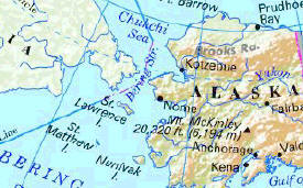
 It is
said that the St. Lawrence River was discovered in 1535 by Jacques Cartier.
But probably the first non-American Indian to visit what is now New York State
was the Italian explorer Giovanni de Verrazano, when he came across
New York Bay sometime in 1524. Around 1609 or so Henry Hudson
claimed it for the Netherlands and in 1624 a settlement at Fort Orange
was established. But the first European to visit what is now the
Jefferson County area was more then likely the French explorer Samuel de Champlain
(1567?-1635) who, in the fall of 1615 (five years before the Pilgrims landed,
eight years after the settlement of Jamestown) with a force of 2,500 Indians,
crossed from the "vicinity of Kingston to Galloup and Stony islands
It is
said that the St. Lawrence River was discovered in 1535 by Jacques Cartier.
But probably the first non-American Indian to visit what is now New York State
was the Italian explorer Giovanni de Verrazano, when he came across
New York Bay sometime in 1524. Around 1609 or so Henry Hudson
claimed it for the Netherlands and in 1624 a settlement at Fort Orange
was established. But the first European to visit what is now the
Jefferson County area was more then likely the French explorer Samuel de Champlain
(1567?-1635) who, in the fall of 1615 (five years before the Pilgrims landed,
eight years after the settlement of Jamestown) with a force of 2,500 Indians,
crossed from the "vicinity of Kingston to Galloup and Stony islands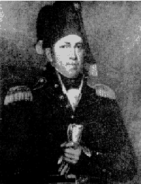 Jacques'
son, James, persuaded his father to allow him to go to America, where he
married a NJ resident and became an American citizen in 1788. New
York became the 11th state on July 26th of this year.
Jacques'
son, James, persuaded his father to allow him to go to America, where he
married a NJ resident and became an American citizen in 1788. New
York became the 11th state on July 26th of this year.
 In 1798 Henry Coffeen (a New Englander living in Schuyler, Oneida
County), Zachariah Butterfield, and Hart Massey (29 years
old, from Vermont) built cabins on what is now
In 1798 Henry Coffeen (a New Englander living in Schuyler, Oneida
County), Zachariah Butterfield, and Hart Massey (29 years
old, from Vermont) built cabins on what is now
 Le Ray made his first trip to the North Country with Governeur Morris
in 1803. They visited
Le Ray made his first trip to the North Country with Governeur Morris
in 1803. They visited


 If you
have any questions, suggestions, or other feedback you can contact me,
the list owner, from one of the locations below:
If you
have any questions, suggestions, or other feedback you can contact me,
the list owner, from one of the locations below: